
The scope of IRRS and IC contribution is twofold:
First it will make available the intensity data points relevant to earthquakes in Europe, gathered in the frame of the BEECD project, which in the last three years investigated the seismicity of Europe from the 16th to the 19th century (Albini and Stucchi, 1997).
Second, the innovative aspect of the research activity will focus on the identification and retrieval of original records on direct or indirect evidence of active faulting.
This first report will describe the state of the art of the latter
research line.
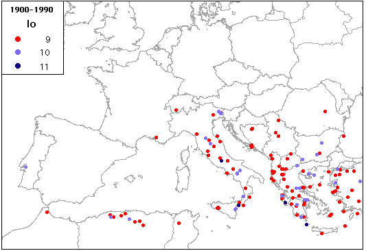
The identification of active faults can be the consequence of a direct approach (retrieval of surface faulting evidence) or can start from considering in which European areas earthquakes with M>6 occurred in the past (Fig. 1a and 1b) and then identifying the active fault zone to which each earthquake could be associated.
The importance of going backward in time by means of historical earthquake records is supported by the fact that for some cases surface faulting or the presence of an active fault could not have been predicted just taking into account this century seismicity, and vice versa.
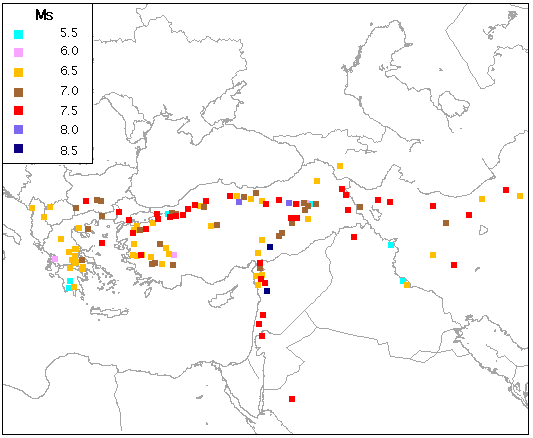
Today knowledge on active faults in Europe derived from historical data is mainly scattered among studies dealing with large earthquakes. An important methodological approach is available for the the Eastern Mediterranean region (Ambraseys and Jackson, 1997); the contribution covers the area shown in Fig. 2a and 2b.
Ambraseys and Jackson identify three "broad categories" to differentiate information on faulting related to earthquakes in the pre-instrumental period:
"A) or a) Strong evidence for surface faulting explicitly (A) or implicitly (a) described in the sources. The length of the rupture is rarely given, and only in few cases can it be reckoned from the distances between the localities which it traversed. [...]
Some examples of the descriptions found for this category are given in Appendix 1. Other accounts of faulting are more explicit but quite a few are only very brief, and yield no further reliable information by being read into.
B) Cases for which surface faulting is not supported by clear evidence can be inferred from the association of a narrow and long epicentral region of a large magnitude earthquake aligning with, or close to, a known fault. Occasionally the length of a break can be reckoned from the length of the long axis of the epicentral region which contains an assumed rupture. Clearly this would not tell us exactly how far the fault-rupture extended, as it may have continued for a greater distance into sparsely populated areas, which we are unlikely to find reported in historical sources, but it will tell us that the shock was probably associated with a surface rupture that can be investigated today in the field. In these cases historical information will not reveal the exact location and rupture length, but it can help to define the time and the segment of the zone that was probably ruptured.
C) Faulting assumed because of the large size (Ms ≥ 7.0) of the associated earthquake and its proximity to a known active fault zone. This category is more tenuous than category B, but it was included to guide further studies. There are many events of Ms ≥ 7.0 that might have been associated with faulting, such as those in and around the Marmara Sea area, in Eastern Anatolia and Iran, but these are omitted as their epicentral area is ill defined."
Such categories allow a better qualification of data with respect
to their reliability in the compilation of a database of active
faults.
Historical data on earthquakes and faults are today available
in formats which are not homogeneous, as it is the case for macroseismic
information. Obviously, the best data are those related to recent,
strong earthquakes, investigated with respect to macroseismic
effects, field surveys, etc.
An intermediate case history is chosen to show the type of information
available on surface faulting evidence. It is a strong earthquake
occurred in northern Albania on June 1, 1905, which is listed
by Ambraseys and Jackson also. The map with the intensity distribution
(Fig. 3) shows that the damage was concentrated in the area of
the Scutari Lake, and that the earthquake was strongly felt in
Apulia (south-eastern Italy) and north in Croatia and on the Dalmatian
coast.

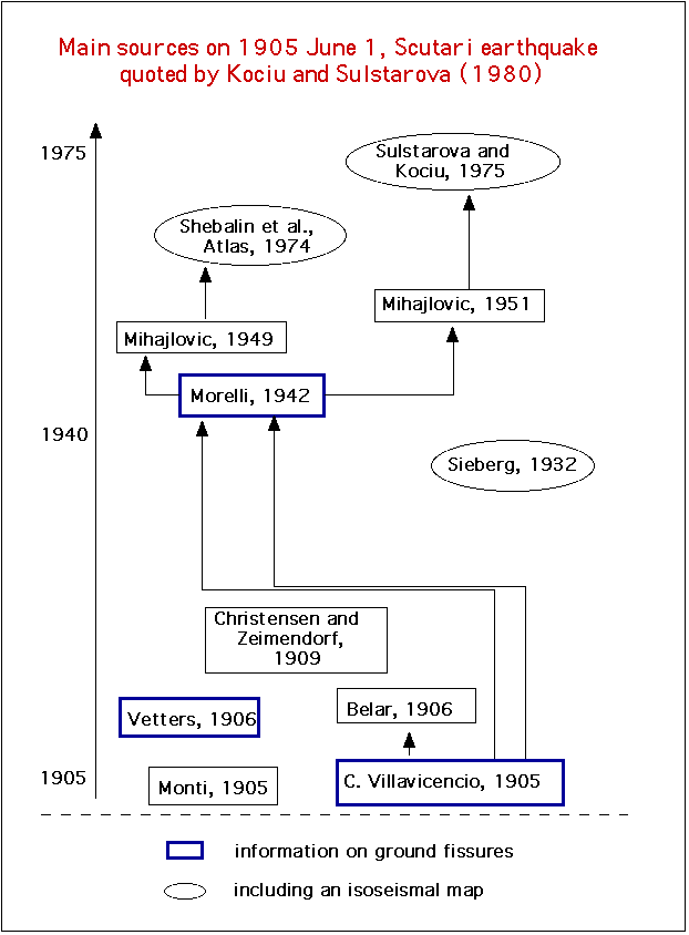
Photos of damaged buldings in villages near Scutari (Figg. 4 and 5) are supplied by the main study on this earthquake (Kociu and Sultarova, 1980), which contains a detailed map of effects in the most damaged area (Fig. 6).


Kociu and Sulstarova (1980) present a detailed description of earthquake effects, in about 20 localities located in the epicentral area, and a summary of natural phenomena associated with the earthquake.
Their data were obtained from :
Information on surface faulting evidence is taken from the authors
shown in Table 1.
| |
"In più luoghi si aprono profonde spaccature, molte delle quali con un margine più alto dell'altro". (In many places deep fissures opened, many with an edge higher than the other) | |
"Auf dem Wege, welcher von Baceleck zur Brucke des Drins fuehrt und sich weiter bis San Giovanni di Medua fortsetzt, entstanden zahlreiche tiefe und weite Kluefte im Erdboden, bei welchem man vielfach beobachten kann, wie ein Rand hoeher als der andere blieb". (Along the road, which leads from Bacelek to the bridge over the Drin and then proceeds to San Giovanni di Medua, many deep and large fissures had opened in the ground, and it could be observed, that an edge remained higher than the other) |
"Von aderveitigen Erdbebenwirkungen sind Erdspalten zu nennen, die sich in der Zadrima besonders am Bojana-Ufer bildeten". (Among the other phenomena, fissures in the ground have to be remembered, which opened in the Zadrima region and especially near the river Bojana) |
It can be observed that the information is not detailed and some -though not substantial - disagreement is evident with respect to the exact location of surface faulting.
In particular, Mihajlovic (1949) does not say what Kociu and Sulstarova
(1980) make him say; their interpretation and location of faulting
evidence across Trush village (Fig. 6) seems therefore to be based
on a comprehensive re-interpretation of data derived from field
investigation and contemporary sources, mainly Villavicencio (1905)
and Vetters (1906).
Historical sources seldom describe effects which can be referred to ruptures or ground deformations induced by earthquakes. In most cases, the description is open to more than one interpretation and should therefore be handled carefully with respect to reliability.
The definition of codes/categories related to the quality of the available information is therefore a useful tool to avoid a misuse of such data.
Albini, P. and Stucchi, M., 1997. A Basic European Earthquake and a Catalogue for the evaluation of long-term seismicity and seismic hazard (BEECD). In: Ghazi, A. and Yeroyanni, M. (Editors), Seismic risk in the European Union, vol. I, Brussels-Luxembourg, pp. 53-77.
Ambraseys N.N. and J.A. Jackson, 1997. Faulting associated with historical and recent earthquakes in the Eastern Mediterranean region. (in press).
Christensen A. and Zeimendorf G., 1909. Les tremblements de terre ressentis pendant l'année 1905. Publications du Bureau Central de l'Association Internationale de Sismologie, Serie B, Catalogues, Strasbourg 1909, pp. 202-217.
Kociu S. and Sulstarova E., 1980. The earthquake of June 1, 1905, Shkodra, Albania; intensity distribution and macroseismic epicentre. Tectonophysics, 67, pp. 319-332.
Mihajlovic, J., 1949. La seismicité de la région du Lac de Scutari. Geofisica Pura e Applicata, vol. XIV, fasc. 3-4, pp. 225-233.
Morelli C., 1942. Carta sismica dell'Albania. Reale Accademia d'Italia, Commissione Italiana di Studio per i problemi del soccorso alle popolazioni, vol. X, Firenze, 120 pp.
Sieberg A., 1932. Erdbebengeographie. In: B. Gutenberg (ed.), Handbuch der Geophysik. Berlin, 4, 3, pp. 687-1005.
Vetters, V.H., 1906. Vorlaufiger Bericht über die Untersuchung des im Sommer 1905 stattgefundenen Erdbeben von Skutari. Anzeiger K. Akad. Wiss., Wien, 1, pp. 4-10.
Villavicencio Carolus, 1905. Letter to A. Belar,
10 July 1905. In: A. Belar, 1906. Die Erdbebenwarte, V, nn. 5-8,
pp. 103-108.