Faust Project description
Summary of the project
Most of the national seismic hazard maps in Europe
are based on Cornell-like approaches, and the seismotectonic contribution
is limited to geometry of the seismogenic zones. Even recent trans-national
approaches in the framework of GSHAP initiative, use this technique, without
taking any advantage of the already available data on active faulting.
The large availability of historical data and the widespread idea that
surface faulting was not observable in Europe, led to methodologies based
on the use of seismogenic faults being dismissed as unfeasible.
Now, on one hand those methodologies are more and
more advanced, with the inclusion of GPS data and modelling of faults interaction.
On the other hand, in recent years the search for seismogenic faults has
become a widely accepted practice in Mediterranean Europe and very recent
advances raise the problem also for Northern European countries.
With this background this project aims at the following:
-
Collect all the available information about individual
seismogenic faults in Europe and implement a data-base on an public-accessible
WWW site (http://www.ismes.it/faust). The consultation of this site will
be guided according to the usefulness of the data to various interest groups
(geologists, seismologists, engineers, civil defence officers).
-
Study sample areas in order to compare different methodologies
for the identification of seismogenic faults (historical data, geomorphology,
paleoseismology, geophysical prospecting, geochemical analysis, GPS methods)
and assess their different reliability, and then incorporate fault information
to create an improved methodology for hazard determination. This will also
allow to compare how different techniques developed also in EC projects
for active fault identification may lead to fault models that have a different
impact and consequences on seismic hazard estimates.
-
For sample areas, perform seismic hazard studies using
different level of accuracy of fault models (a line in a plane, a plane
in space, 3-d structures interacting in time) coupled with different statistical
models (stationary and time-dependent) in order to assess the variation
both in absolute value and in accuracy of the estimates.
Three main guidelines will be followed to guide the
investigation.
As a first point, the proposers bear in mind that
too often the main problem in transferring the information from geologists
to seismologists and engineers suffered from the absence of a feedback
about the usefulness of the data. For example, a geological map reporting
all the surface cracks, breaks and settlements observed in the field may
be useless if not misguiding for the seismologist that wants to start his
simulations from the single seimogenic fault which is responsible for all
the observed ground features: seismologists and engineers needs to select
models according with the available geological and historical data and
vice-versa. Thus a clear correlation between field observation and seismogenic
structure is the prerequisite for the inclusion in the data base, in order
to avoid the confusion between the so called "active faults" and those
that are actually responsible for significant earthquakes. The reason for
this misunderstanding may arise on the one hand from the fact that traditional
structural geologists deal with observation of upper crustal complexity
that may have no bearing on the potential complexity of a future earthquake.
On the other hand, seismologists and engineers need to extract from the
geologists' knowledge information that is compatible with the (usually
limited) complexity and (normally long) scale length of their models.
The second point is that as any mature scientific
technique, geology must not confuse the observations with its interpretations
and should always attach an uncertainty estimate to the data it provides.
This uncertainty may arise from two factor: one intrinsic to the data (observation
technique used, like limited trenching of an extended fault), and the second
one deriving from the conversion of observation in a model. Any model can
be suitable, according with the data available, but it must be clear that
their use by seismologist is restricted according to the characteristic
of the models. E.g., a study on the dynamical interaction between faults
cannot be performed using only fault's projected intersection with the
surface, or simply the estimated length of a fault surface projection should
not be used straightforward to infer maximum magnitude without any other
consideration about reliability itself, seismogenic depth, rock mechanical
characteristic and expected stress drop (end users tend sometime to forget
that the fault length vs. magnitude relationship is obtained using a set
of observed surface ruptures, but the faults able to produce ground
breaking are not the whole family of seismogenic faults, that include also
members that produce only limited coseismic surface ruptures or are positively
blind: The inferred length of fault surface projection should be
treated as a model with its uncertainty, not as a datum).
The third point is that the dimensional difference
between faults and the representation of the world in which fault models
are used should not exceed unity: a linear fault model is suitable only
in a plane view of the studied area, a fault plane model is to be inserted
in a 3-dimensional seismicity model with no time dependence, a fault plane
with characteristics varying in time is suitable to study of 3-d fault
interaction in time.
Project
workprogramme
The steps (or subtask) of the project are the following:
1. Study of seismogenic sources
2. Comparison of hazard estimates
3. Building of an European active fault data-base
on a WWW site
Study of
seismogenic sources
As a preliminary step towards the goal of the project,
a map of the largest historical earthquakes in Europe will be implemented
in the WWW data base as a reference starting point to locate the earthquakes
that must have produced observable faulting. Refinement of the available
data (such as the method for deriving fault parameters from intensity data
developed in the EC project SCENARIO) will lend further support to geological
studies.
The proposed project aims at maximising the extent
and the quality of the geological input in computing earthquake hazard.
The ultimate goal of this first step is to provide the location, geometry,
size, style, maximum expected earthquake and recurrence characteristics
of all the seismogenic sources according with the principle that a different
level of the information gathered on the field may lead to different fault
models of increasing order of detail and complexity.
To accomplish the above mentioned goals the project
will:
For the whole of Europe:
-
collect all the available results produced in the
field of seismogenic fault identification;
-
promote the maximum exploitation of data concerning
large historical earthquakes, taking advantage of the experience acquired
by the Environment project BEECD;
-
prepare the data to be included in the WWW database,
classifying faults according to the different level of reliability of field
observation and thus model accuracy.
For the test areas of Calabria (Italy), SE Iberian
Fault System (Spain) and Hellenic Arc (Greece):
-
gather all existing data plus original observations
on the state and age of deformation of young geological horizons and landscape
features, using both standard paleoseismological techniques and general
field and remote-sensing methods.
-
gather instrumental data including: a) seismological
data that may illustrate the local patterns of seismic release, b) high
resolution seismic surveys to be performed in the Calabria area, c) geochemical
mapping aimed at identifying faults by gas emission, using a low-cost approach,
d) continuous GPS measurement performed by three stations operated in the
Calabria area by ING, e) satellite data.
-
develop a model where all seismogenic sources are
shown to be consistent with all existing plate-motion, geodetic, historical
and surface geology constraints. Depending on the type of surface expression
of the sources (i.e. whether they are surface-breaking, hidden or blind)
the identification will be based on direct observations, on modelling of
selected geological and landscape features, or simply on the extrapolation
of observations and estimates obtained for adjacent sources.
The results of the first step will be formatted in
a way that is immediately suitable for obtaining forward models of the
expected ground motion and for subsequent verifications against observed
felt reports.
Comparison
of hazard estimates
In order to assess how much different fault models
change the image of seismic hazard, several techniques will be used and
compared, and namely:
-
creation of a reference set of maps, based on the
full exploitation of historical data only, including observed intensity
at each site, but without any input from geology;
-
time-independent seismic hazard estimate substituting
to the Cornell's seismogenic areas used for a national estimate the 2-d
sources derived from seismogenic faults (test on the influence of geometry);
-
as the above, but including where available characteristic
models of faulting and information on return times (test on first level
time-dependence);
-
deterministic (scenario-like) estimate of ground motion
imposing the maximum expected event on each fault, using an hybrid model
for 3-d faults (test on second level of geometry influence)
-
study of variability of earthquake occurrence probability
on a fault as a consequence of interaction with pattern of the stress released
in space and time by the surrounding faults (test on a full-scale time
dependence)
Reference Hazard Model
The statistical estimates performed to validate the
subsequent results and to verify their reliability will incorporate observed
damages due to past earthquakes directly into site hazard estimates. The
technique that will be used for seismic hazard estimates using historical
data was developed by one of the partner, and is has already been used
for seismic hazard estimates on several sites in Europe. The main outcome
of this analysis will be the probability that a given intensity may be
felt during an assigned period of time. This will allow comparison with
the occurrence ratio of earthquakes deduced by the seismogenic fault models.
Time-independent hazard model
For the test areas considered there are available
seismic hazard estimates based on Cornell's approach. For that areas the
incorporation of active faulting will have a first step aimed to verify
how much seismic hazard estimates are sensitive to the geometry of the
fault zones. In practice, a first attempt will be made assigning all the
seismicity relevant to a seismogenic area to the active fault(s) present
in that area. To this scope it will be possible to use all the identified
faults, since the only parameters required are geometrical. For selected
faults having data on slip rates or recurrence times it will be possible
to include this information in estimate of activity rates as well as in
frequency-magnitude distribution.
A side benefit of this analysis will be a contribution
to the widespread debate on the distribution underlying extreme events.
According to several authors characteristic earthquakes do not follow Gutemberg-Richter
distribution and their behaviour is separate from background seismicity.
To others this fact is apparent and due to incompleteness in the catalogues
that are too short if compared with the length of a seismic cycle. The
most active areas of Europe may provide a very important test to both hypotheses,
since the very long duration of the historical catalogues may match the
duration of seismic cycles deduced from active faulting studies.
Deterministic ground motion estimate
The ground motion waveforms radiated by extended faults
can be modelled by means of deterministic approaches based on a kinematic
representation of the seismic source. While a dislocation model is sufficient
to simulate the seismic radiation at low frequencies (f < 1 Hz), it
is well known that the high frequency radiation is associated to the details
of the rupture front propagation on the assumed fault plane and to the
details of the medium where seismic waves are propagating. In recent years
the attention of the investigators has been focused on the description
of these two effects: the propagation in complex media and the complexity
of the earthquake ruptures. The possibility of proposing reliable rupture
scenarios for sites of engineering interest depends on the knowledge of
the dimensions, of the geometry and of the rupture history on extended
faults. The complexity of the seismic source is manifested in rupture models
obtained by the inversion of ground motion waveforms, as well as the crustal
heterogeneity results from tomographic images. Thus, there exists an evident
limitation in proposing deterministic source models for simulating the
high frequency radiation. The analyses of ground motion time histories
indicate that the high frequency accelerations recorded near the seismic
source are generally incoherent. Although, this incoherence is in part
the result of scattering and multipathing, it also manifests the dynamic
heterogeneity of the rupture process. This makes the modelling of ground
accelerations in the time domain extremely difficult. For these reasons
ground acceleration has only been analysed in time domain after low-pass
filtering or in the frequency domain after smoothing the high frequency
spectral amplitudes. In order to overcome the difficulties resulting from
the incoherence of recorded ground accelerations, the stochastic simulation
methods were proposed in the earthquake engineering practice. In this approach,
the ground accelerations are simulated by generating random sequences whose
amplitudes and durations are fixed by an adopted spectral model to account
for source and attenuation contributions. These methodologies allow to
reproduce, in a statistical sense, the peak values predicted by empirical
regressions on experimental data. In particular, these methodologies are
useful to extend the scaling of peak ground motions and response spectra
outside the interval of magnitude and distances where the regressions were
computed. However, the stochastic approaches have the limitation that they
do not take into account for the amplitude variations of the ground motions
simulated at observers having different azimuths. Moreover, the duration
of the ground motion waveforms simulated by the stochastic methods depends
mostly on the value adopted for the corner frequency. Based on the recent
experience gained by two partners, we propose to use an original hybrid
method, that allows to join the advantages of the deterministic simulation
procedures (such as the correct source-to-observer geometry, the true duration
of the rupture process modulated by directivity) to the stochastic approach
that guarantees a random phase. The strategy of simulation is to compute
the envelope of ground acceleration by using deterministic coherent source
models and to use this envelope function in the stochastic simulation scheme.
This hybrid method allows to compute incoherent ground accelerations, whose
amplitudes and durations change as a function of the observer position
(distance and azimuth) and of the rupture model (rupture velocity). This
approach seems to be a promising and useful tool to predict the ground
shaking at sites where no strong motion recordings are available. Even
if there exist numerical procedures that allows to simulate the ground
motions by means of incoherent source models, where the slip distribution
is heterogeneous and the rupture front propagates at variable rupture velocity,
we believe that such a model cannot be used to make predictions of ground
motions for engineering purposes. This is the reason that motivated us
to compute the envelope of ground motion, to be used in the stochastic
procedure, by means of coherent rupture models whose parameters can be
constrained by independent available seismological information. We aim
to simulate the acceleration time histories for different rupture scenarios
for municipalities included in the case study area.
Full scale fault interaction
Over the last 5 years a number of research groups
have demonstrated that earthquakes occur in places where previous events
have increased the "Coulomb Stress". This has been shown to apply both
to aftershock sequences over time scales of days to weeks and to the interactions
of large events over 10s of years. An example of such interactions is shown
for 5 events in the Aegean trough (figure in the following page) and has
been extended to cover 19 events between the 1912 and the present for the
Aegean and for the events along North Anatolian fault since 1943. Of the
all events in the these two studies only one does not clearly fall into
a region where coulomb stresses have been increased by earlier events.
Such consistency strongly suggests that the likely sites of future events
can be effectively constrained by these methods.
Until now Coulomb modelling has exclusively employed
information derived from earthquakes that have been studied instrumentally
and in many cases events for which surface faulting was mapped after the
earthquake. The start time of such studies must therefore be relatively
recent and uncertainty exists because of the Coulomb stresses due earlier
events have not been included. This is particularly important for areas
of relatively low seismicity where seismic cycles are long and hence few
previous events have enjoyed detailed study.
This problem can be alleviated using data from
active fault mapping and the data collated in this project will be used
to define zones of particular future hazard by including them in Coulomb
modelling.
Building
an European active fault data-base on a WWW site
The projects will exploit the potential of Internet
and of the World Wide Web both in the development phase, when data will
be defined and collected, as well as in the dissemination phase, when the
results of the research will be made available to the world at large.
After an initial step, in which exchange formats
and operating procedures will be defined and agreed upon, project participants
will exchange project documents, reports, images, memos, personal communications
as well as georeferenced data (maps, measurements, etc.) in an electronic
fashion. In addition and in alternative to the usual point-to-point connections,
such as electronic mail and file transfers, the information flow will be
supported by a central site which will make available all the documents
through an easy-to-use WWW interface. It will be therefore possible to
share discussions and results among all partners in a fast, convenient
and cost-effective fashion, minimising the need for travel. Moreover, the
electronic availability of results will make it easier for the Community
officers to monitor the progress of the project. When eventually the database
will be available and released, the general public will easily access it
through a World-Wide-Web interface.
Project development phase
The project development phase will entail defining
and using a set of conventions for exchanging information among partners,
through the support of a Internet site. Using the project planning documents
and standard modelling tools, such as Petri Nets, a formal model of the
information flow will be created. The next step will be to build a central
Internet site maintaining the following main types of information:
-
the authorised users, their main personal data and
their passwords.
-
a repository of messages and documents
-
a repository for seismological data in several formats
-
a model describing how and when each user will interact
with each of those repositories.
Specifically, the model will be implemented through
a set of Common Gateway Interface (CGI) scripts on a World-Wide-Web site,
so that each user will be recognised and will be presented with a menu
containing only the options which are available at that specific time,
depending on the current development phase of the project. For instance,
it will be possible to make comments on a given document only after the
draft version of that document will have been circulated.
The main functionalities available in this phase
will include:
-
submitting messages to a project-wide mailing list,
which will reflect each message to each involved person, thereby providing
a forum which will foster the development of a common technical background
among all partners. Messages will be archived and it will be possible to
retrieve past messages through the Web. Several different mailing lists
may be created if required.
-
submitting draft, intermediate and final versions
of reports in an agreed format (e.g. RTF). They will be entered in a collection
available to all authorised people.
-
transferring database data to and from the central
site, so that each partner may work on the relevant part of the central
database. User identity will be certified through a password mechanism,
so that each user will be made responsible for its own data.
-
validating the submitted data, so that adherence to
standard formats will be tested on line, shortening the time-consuming
of generating data in the right format through distribution and validation
of tapes or diskettes.
-
testing the database by generating maps from the available
data. The functionalities of the database are better explained in the following
paragraph.
We plan of creating the site using a UNIX workstation
with an industry-standard web server (e.g. Apache); the scripts necessary
to handle the interaction will be developed using the Perl and C languages.
For the creation of maps and for performing on-line calculations a choice
will be performed among several commercial and public-domain packages which
provide Geographic Information Systems (GIS) functionalities through a
Web interface, notably those from Mapinfo Corporation and ESRI Inc.
In the deployment phase, the project development
capabilities of the FAUST system will be of course removed, while the general
public will access the main functionalities of FAUST through the World-Wide-Web
interface.
The main functionalities to be implemented will
take into account similar projects developed at a national scale and include:
-
displaying a map of the relevant area, with several
geographic features such as elevation models, drainage models, cities,
etc., at several scales.
-
displaying seismogenic faults with appropriate symbols,
and inquiring the system about attributes related to the fault selected,
such as location and geometry, relevant bibliography, history, seismic
behaviour, pictures and maps, etc.
-
displaying measurements from instruments on the map.
-
displaying earthquake location from existing catalogues
and providing details on selected ones.
-
performing on-line calculations
The technology used will be essentially the same as
in the former paragraph. The public might have access during the preparatory
phase and see how the final results (e.g., hazard maps) are updated by
the ongoing studies.
PROJECT
MILESTONES AND DELIVERABLES
The structure of the project advancement monitoring
will follow the scheme adopted by the coordinator in previous successful
projects in the ENVIRONMENT and TACIS frameworks.
The basic principle is that there is a coincidence
among milestones, deliverables and project tasks. This means that each
project task must provide a deliverable (a stand alone one or as an input
to subsequent tasks) and the fulfillment of the task with the issuing of
the associate deliverable constitutes by itself a milestone to judge the
advancement status of the project.
The proposed time schedule is reported in the following
scheme:
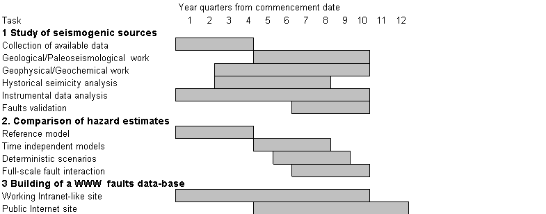
At the completion of each one of the 12 sub-task
listed above, a detailed technical report concerning the performed activities
will be issued. Those reports will also constitute the backbone of official
reporting toward EC (progress and yearly reports). Again, it is to be stressed
that during the project lifetime the development of a WWW site (with access
initially restricted to participants and EC officers) will be the most
transparent possible mean of monitoring the project achievements. On this
WWW site, the above mentioned reports (deliverables) will be available
to participants and EC officers since their draft stage, and after that
they will be released on the public-accessible domain.
The WWW public site that constitutes the main final
deliverable of the project will be accessible to demonstrate in real time
its advancement status, as well as the status of the products it will contain
(hazard maps at various stages, fault maps, fault data-base, etc.)
The proposers believe that the possibility offered
to EC officers to connect whenever they want to the restricted WWW site
is, at the present state of the art, the most flexible and inexpensive
option possible to follow at maximum detail the project advancements. Of
course, this will not substitute the usual procedure of official reporting
and accounting, but will permit to have a continuous check of the project
without having to wait for the fixed milestones.
Four plenary meetings will be organized: one at
the start, one before the end of first year and the sumbission of the annual
report, one before the end of second year and the sumbission of the annual
report, one before the end of third year and the sumbission of the final
report. They will be in form of workshop open to the contractors, scientist
working on the project. During the mid-term review meeting (in the middle
of second year) and the final meeting, two independent observers will be
invited, and their names will be decided in consultation with the scientific
officier.
THE
PARTNERSHIP
The role of the partners is summarised in the following
scheme:
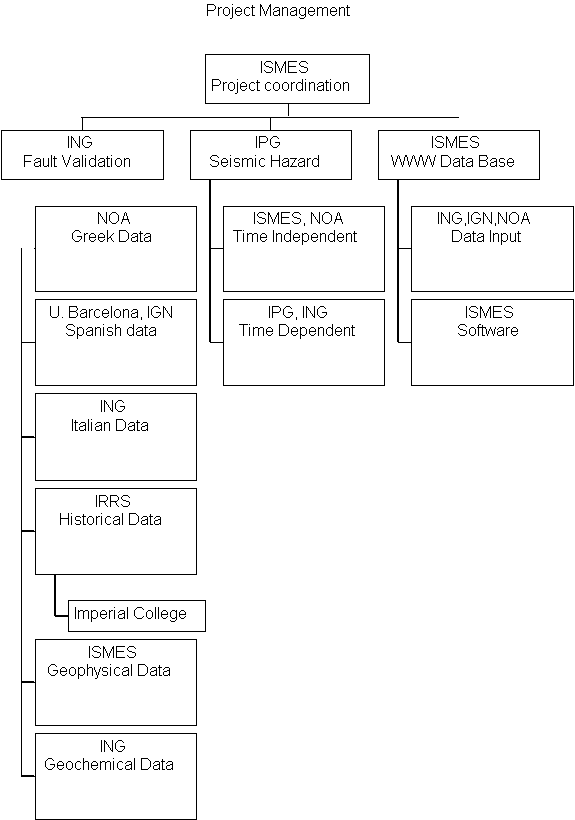
ISMES activity in the project is divided in the
following:
-
Coordination and Management
-
Seismic hazard estimates
-
High resolution seismic profiles on Calabria test
site
-
Preparation of WWW site
IPG activity in the project will be focused on:
-
Seismic hazard estimates
-
Models of full scale faults interaction
ING will:
-
coordinate national research on identifying, mapping
and trenching large Italian faults
-
continue developing the pilot project of a GIS-based
Catalogue of Italian Seismogenic Faults
-
cooperate with scientists of Greece and Spain to develop
local fault catalogues through the implementation of software procedures
and the validation of the data to be input
-
develop techniques to study fault interaction systematically
using the fault catalogues developed within the project, with particular
emphasis to the implications for seismic hazard
The main goals of the IGN are:
-
to cooperate with the other partners, particularly
with ISMES, in building an European Active Fault Database on a WWW site.
Close cooperation during the project development will be especially important
in order to build an efficient system.
-
to introduce in the system data already available
at IGN concerning Spain historical seismicity, instrumental seismicity,
topography, and other geographical information.
to implement, in cooperation with the University of
Barcellona (UB), the data about faults that exhibit Quaternary activity
and the seismogenic parameters of specific faults.
The main goals of the UB group will be:
-
To compile the existing relevant information regarding
Spain. Information on the active faults during Quaternaty is available
over the whole country
-
In relation to the compilation mentioned above, perform
more specific studies in order to understand better the characteristics
of some important faults, especially on the eastern margin of the Iberian
Peninsula.
IRRS (that will take as sub-contractor the Imperial
College) will:
-
provide and analize data from European historical
earthquakes
-
retrieve data on active faulting data forcountries
not participating in the project
The N.O.A. will undertake the following research tasks:
-
collection of historical - instrumental Data: a uniform
data base for the Hellenic arc will be prepared
-
seismic hazard estimate in the test Greek area by
using the concepts of the classical and Bayesian statistics and by incorporating
historical, instrumental and geological data.
-
deterministic estimate of the ground motion waveformsfor
the characteristic earthquake for the test area.
INTERACTION
WITH OTHER PROJECTS
Among the project shortlisted for fundings for the
Environment IV Framework, some intercation is envisaged with the following
two:
-
The first one is the project co-ordinated by Dr. Salvaneschi
at ISMES (SEISMOCARE).The objective of the project is to develop an integrated
methodology and the necessary software system, tailored around a knowledge
based software package, to support seismic risk mitigation decisions for
a town and for its future expansions, in order to optimise the planning
process from a social and economic viewpoint. The hazard evaluation for
the a test site will take advantage of the results of the project FAUST:
one of the three test sites of the project is indeed the Hellenic Arc,
including the town of Hania.
-
The second one is the project co-ordinated by Dr.
Megrahoui. Aim of the project is the study of active faulting in Northern
Europe. The results of this project may eventually be included in the FAUST
WWW data-base. Information exchange on common issues is also foreseen.
back
to home page