The
Catalogue lists seismogenic sources subdivided into three major categories:
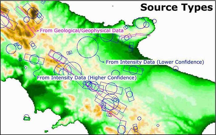
Sources
from Geological/Geophysical Data (Type A sources) are the best quality
sources and are shown in purple colour. For these sources all spatial,
geometric and kinematic parametres are always specified.
Sources
from Intensity Data at Higher Confidence Level (Type B sources) were
obtained exclusively from the intensity data of an individual large earthquake
(M equal or larger than 5.5) and are shown as oriented boxes.
Sources
from Intensity Data at Lower Confidence Level (Type C sources) were
also obtained from intensity data, but due to the limited information available
they are shown simply as circles.
Sources are then selected:
-
directly from the Cartographic
Interface using the pointer  ,
either one by one or collectively depending on the current map scale (this
is controlled by the width of the pointer with respect to the width of
the lines used for representing the sources)
,
either one by one or collectively depending on the current map scale (this
is controlled by the width of the pointer with respect to the width of
the lines used for representing the sources)
-
from the Access by source list
 by browsing and clicking the full
source list. A specific button then allows the user to browse the source
parameters or to locate the source on the Cartographic
Interface.
by browsing and clicking the full
source list. A specific button then allows the user to browse the source
parameters or to locate the source on the Cartographic
Interface.